
Hawaii is renowned for its stunning beaches, lush landscapes, and vibrant culture, but beyond the popular tourist destinations lie hidden enclaves where tranquility and natural beauty reign supreme. These secluded neighborhoods offer a glimpse into a more peaceful side of island life, where residents enjoy privacy, breathtaking scenery, and a strong connection to nature.
Whether you’re seeking a quiet retreat or curious about Hawaii’s lesser-known communities, join us as we explore ten of the most secluded neighborhoods across the Hawaiian Islands.
10. Peahi – Maui’s Hidden Countryside

Nestled on Maui’s north shore, Peahi is a rural area known for its expansive agricultural lots and serene environment. This countryside gem offers residents large plots of land amidst rolling fields and lush forests, providing ample space and privacy.
Peahi is famous for “Jaws,” one of the world’s most renowned big-wave surf breaks, attracting surfers during the winter months. With a small population, the community maintains a peaceful atmosphere away from the hustle and bustle of tourist hotspots. The natural barriers and minimal development in Peahi create a private, tranquil environment that embodies the essence of secluded island living.
Where is Peahi?

Peahi is located on the north shore of Maui, between the towns of Paia and Haiku. Accessible via Hana Highway and turning onto Peahi Road, the area is off the beaten path and requires a bit of navigation through narrow country roads.
The geography includes cliffs overlooking the ocean, dense forests, and fertile farmland, contributing to its secluded nature. Visitors can reach Peahi by driving east from Kahului Airport for about 30 minutes, experiencing Maui’s scenic northern coastline along the way.
9. Hakalau – Remote Coastal Area on the Big Island

Hakalau is a small, unassuming community nestled along the Hamakua Coast of the Big Island. This sparsely populated area boasts expansive properties overlooking the Pacific Ocean, offering residents unmatched serenity and stunning views. The neighborhood is surrounded by lush gulches, cascading waterfalls, and historic sugar plantation remnants, providing a rich backdrop for outdoor exploration.
With a close-knit population of around 300 people, Hakalau maintains a quiet, rural charm far removed from urban congestion. Its secluded setting makes it an ideal retreat for those seeking a peaceful lifestyle immersed in nature.
Where is Hakalau?

Located approximately 15 miles north of Hilo, Hakalau sits along the scenic Mamalahoa Highway on the northeastern coast of the Big Island. The area is characterized by its dramatic cliffs, deep valleys, and verdant landscapes fed by ample rainfall.
Accessing Hakalau involves a leisurely drive along the Hamakua Coast, renowned for its panoramic ocean vistas and picturesque roadside scenery. The region’s geography, with its steep terrain and limited infrastructure, contributes to its secluded atmosphere, making Hakalau a hidden gem awaiting discovery.
8. Hawi – Quiet Hamlet in North Kohala

Hawi is a charming village located at the northern tip of the Big Island, known for its welcoming community and laid-back vibe. This quaint hamlet features large lots nestled amid rolling green hills and old-growth trees. Hawi’s rich history as a former sugar plantation town adds to its unique character, with art galleries, boutiques, and cafes lining the main street.
The population of around 1,000 residents enjoys a serene environment far from crowded tourist centers, embracing a slower pace of life. Outdoor enthusiasts can explore nearby Pololu Valley and enjoy hiking, horseback riding, and breathtaking coastal views.
Where is Hawi?

Hawi is situated in the North Kohala district on the Big Island of Hawaii, approximately 54 miles north of Kailua-Kona. The village is accessible via the Akoni Pule Highway (Highway 270), which offers a scenic drive along the island’s rugged coastline and through pastoral landscapes.
Hawi’s remote location at the island’s northern end contributes to its tranquil atmosphere and sense of seclusion. Visitors can reach Hawi by car, taking in the picturesque views of the Kohala Mountains and the expansive Pacific Ocean along the way.
7. Kualapuu – Tranquil Village on Molokai

Kualapuu is a small, rural community located in central Molokai, known for its peaceful ambiance and agricultural heritage. With large land parcels surrounded by pineapple fields and open countryside, residents enjoy ample space and a close connection to the land.
The village is home to the famous Coffees of Hawaii plantation and offers a glimpse into traditional Hawaiian lifestyle. With a population of just over 2,000 people, Kualapuu exudes a sense of camaraderie and simplicity. The area’s distant location from major towns enhances its secluded feel, making it a haven for those seeking tranquility.
Where is Kualapuu?

Located approximately 5 miles northwest of Kaunakakai, the main town on Molokai, Kualapuu is accessible via Highway 460. The village sits at a higher elevation, offering cooler temperatures and sweeping views of the island’s central plains.
Molokai’s limited development and lack of traffic contribute to Kualapuu’s serene environment. Visitors can reach Molokai by plane from Honolulu or Maui and then drive a short distance to Kualapuu, immersing themselves in the island’s unspoiled natural beauty and relaxed pace.
6. Naalehu – Southernmost Community on the Big Island

Naalehu is the southernmost community in the United States, located in the Kaʻū district of the Big Island. This quiet, small town is surrounded by vast open spaces, rolling hills, and volcanic landscapes, offering a unique and secluded living experience.
With large agricultural lots, residents often engage in farming and ranching, embracing a self-sufficient lifestyle. Naalehu has a population of about 900 people, fostering a tight-knit community atmosphere. The town’s slow-paced lifestyle and remote setting make it an ideal retreat from the fast-paced nature of urban centers.
Where is Naalehu?

Naalehu is situated along Highway 11, approximately 65 miles south of Hilo and 65 miles southeast of Kailua-Kona. The town lies near the southern tip of the Big Island, providing access to attractions such as the Green Sand Beach at Papakōlea and Punaluʻu Black Sand Beach.
The geography includes rugged coastlines and expansive pastures, contributing to its secluded character. Visitors can reach Naalehu by driving along the scenic Mamalahoa Highway, enjoying views of Mauna Loa and the vast Pacific Ocean along the journey.
5. Miloliʻi – Hawaii’s Last Fishing Village

Miloliʻi is a small, unincorporated community located on the southwestern coast of the Big Island. Known as “Hawaii’s Last Fishing Village,” it has a population of approximately 300 residents. The community maintains a traditional Hawaiian fishing lifestyle, with many locals relying on fishing as their primary source of income.
Visitors to Miloliʻi can experience authentic Hawaiian culture, explore coastal trails, and engage in ocean activities such as snorkeling and kayaking. The village’s seclusion stems from its remote location and limited infrastructure, with homes often utilizing solar power and rainwater catchment systems due to the absence of public utilities.
Where is Miloliʻi?

Miloliʻi is situated approximately 33 miles south of Kailua-Kona on the Big Island. Its isolation is accentuated by the rugged coastline and the lack of major roadways leading into the village.
Access is primarily via the narrow and winding Miloliʻi Road, which descends from the Hawaii Belt Road down to the coastal community. The challenging terrain and distance from urban centers contribute to Miloliʻi’s tranquil and undisturbed atmosphere, offering a glimpse into a way of life that has persisted for generations.
4. Maunaloa – Sleepy Village on Molokai

Maunaloa is a small village located on the western end of Molokai, known for its panoramic ocean views and peaceful surroundings. The community features large plots of land and is surrounded by open fields and rolling hills, providing residents with ample space and privacy.
With a population of around 350 people, Maunaloa offers a tight-knit community feel. The lack of commercial activity and its remote location make it an ideal secluded retreat for those looking to escape the hustle and bustle of city life. The area embodies the slow-paced, friendly vibe that Molokai is famous for.
Where is Maunaloa?

Maunaloa is situated approximately 16 miles west of Kaunakakai, the main town on Molokai. Accessible via Maunaloa Highway (Highway 460), the drive offers scenic views of the island’s western plains and coastline.
The village sits at an elevation, providing cooler temperatures and sweeping vistas of the Pacific Ocean and nearby islands. The limited development and sparse population in this part of Molokai contribute to Maunaloa’s secluded atmosphere, making it a perfect getaway for those seeking solitude.
3. Puako – Quiet Coastal Community on the Big Island

Puako is a small, tranquil neighborhood located along the Kohala Coast of the Big Island. Known for its spacious oceanfront properties and minimal commercial development, Puako offers residents serene ocean views and a relaxed lifestyle. The area is a haven for marine life enthusiasts, with easy access to snorkeling, diving, and tide pools teeming with sea creatures.
With a population of approximately 700 people, Puako maintains a close-knit community feel. The surrounding lava fields create natural barriers, enhancing the sense of privacy and seclusion from larger towns.
Where is Puako?

Puako is situated between the resorts of Mauna Lani and Hapuna Beach on the northwest coast of the Big Island. Accessible via Puako Beach Drive off Queen Ka’ahumanu Highway (Highway 19), the neighborhood is about a 30-minute drive north of Kailua-Kona.
The area’s geography includes rocky shores and ancient lava flows, providing a unique and rugged coastal landscape. The secluded beaches and quiet streets of Puako make it a hidden gem for those seeking a peaceful seaside retreat.
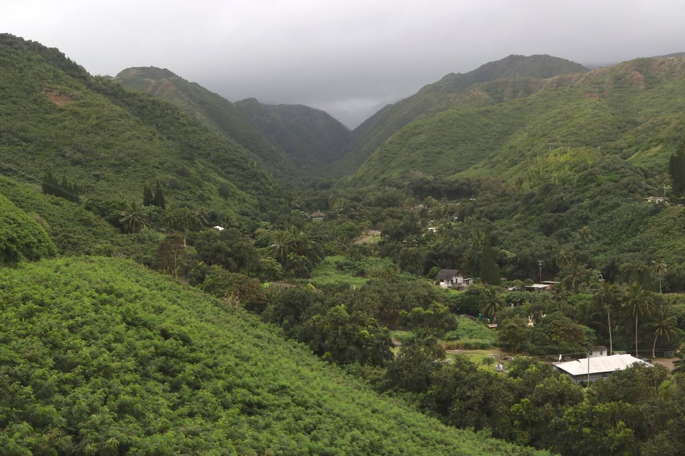
2. Kahakuloa – Secluded Valley on West Maui

Kahakuloa is a hidden village nestled between towering cliffs on Maui’s northwest coast. Accessible only by a narrow, winding road, this secluded community offers a glimpse into traditional Hawaiian life. The village is home to less than 100 residents living in traditional homes on large plots surrounded by lush vegetation.
Kahakuloa’s isolation and dramatic natural barriers provide residents with unparalleled privacy and tranquility. Visitors can experience local crafts and homemade treats, immersing themselves in the authentic culture of the area.
Where is Kahakuloa?

Kahakuloa is located along Maui’s Kahekili Highway (County Route 340), northwest of Wailuku. The drive to the village is an adventure in itself, featuring narrow roads, sharp bends, and breathtaking coastal views.
The geography includes steep cliffs, verdant valleys, and a rugged coastline, all contributing to its secluded nature. Accessing Kahakuloa requires careful navigation, but the journey rewards visitors with stunning scenery and a peaceful atmosphere far removed from Maui’s bustling tourist centers.
1. Kipahulu – Maui’s Remote Coastal Village

Kipahulu is a remote community located beyond Hana in East Maui, offering a truly secluded experience. Nestled amidst lush rainforest and cascading waterfalls, Kipahulu provides residents with large agricultural lots and an intimate connection to nature.
The area is adjacent to Haleakalā National Park, allowing easy access to the famous Pipiwai Trail and the Seven Sacred Pools at ‘Ohe’o Gulch. With a small population of around 100 people, the village maintains a tranquil atmosphere. The rugged terrain and distance from urban centers offer unparalleled seclusion in one of Maui’s most pristine environments.
Where is Kipahulu?

Located approximately 12 miles south of Hana, Kipahulu is accessible via the Hana Highway (Highway 31), which continues beyond Hana as a narrow, winding road. The journey to Kipahulu involves navigating through dense rainforests and along dramatic coastal cliffs, showcasing some of Maui’s most breathtaking landscapes.
The area’s remote location and challenging access routes contribute to its secluded character. Visitors can reach Kipahulu by continuing past Hana and following the signs to Haleakalā National Park’s Kipahulu District, where they can explore the area’s natural wonders.