Nestled within the vast and rugged landscapes of Oregon’s high desert are towns that offer a retreat into tranquility and natural beauty. Far from the bustling cities, these secluded communities provide a glimpse into a slower pace of life, rich with history and surrounded by striking geological wonders. Whether you’re seeking a quiet escape, an adventure through unique terrains, or a journey back in time, these towns hold hidden gems waiting to be explored. Join us as we count down ten of Oregon’s most secluded high desert towns, each with its own charm and stories to tell.
10. Fort Rock: History Amidst Isolation

With a population of fewer than 25 residents, Fort Rock is a tiny community steeped in history and surrounded by remarkable volcanic formations. Visitors can explore the Fort Rock State Natural Area, where an ancient volcanic tuff ring rises dramatically from the flat landscape, offering hiking trails and panoramic views. The town is home to the Fort Rock Valley Historical Homestead Museum, showcasing preserved homestead buildings that tell tales of early settlers. Agriculture and ranching are the primary industries, reflecting the town’s roots in farming heritage. Fort Rock’s seclusion is highlighted by its open horizons and the quiet that envelops the town, making it a peaceful retreat for those looking to disconnect.
Where is Fort Rock?

Fort Rock is located in Lake County, in south-central Oregon’s high desert region. Its remote setting is amplified by miles of surrounding sagebrush and the absence of nearby major highways. The town sits about 70 miles southeast of Bend, accessible via a network of rural roads that enhance the sense of journeying into the wilderness. This isolation, coupled with the stark beauty of the volcanic landscape, makes Fort Rock a unique destination off the beaten path.
9. Solitude in Christmas Valley

Christmas Valley, with approximately 1,000 residents, offers a tranquil atmosphere amid sprawling sand dunes and lava fields. Outdoor enthusiasts can enjoy activities like off-roading on the Christmas Valley Sand Dunes or exploring the mysterious Crack in the Ground, a volcanic fissure over two miles long. The local economy centers around agriculture, particularly alfalfa farming, and small businesses serving the community. Its seclusion stems from the vast open spaces and the sense of quiet that pervades the area, providing a serene environment away from urban noise.
Where is Christmas Valley?

Situated in the northwestern corner of Lake County, Christmas Valley lies about 100 miles southeast of Bend. The town’s remote location is accentuated by the surrounding high desert terrain and the lack of major transportation routes. Access is primarily via State Route 31, known as the Fremont Highway, followed by county roads that lead into the heart of the valley. This isolation makes it a perfect getaway for those seeking solitude amid Oregon’s expansive desert landscapes.
8. Fields: The Far-Flung Frontier

Fields is an unincorporated community with a population of less than 20, making it one of Oregon’s most remote settlements. Visitors can experience the Fields Station, a combination cafe, motel, and gas station famous for its homemade milkshakes—a welcome treat in the high desert heat. The area is ideal for bird watching, rockhounding, and soaking in nearby hot springs. Ranching is the primary industry, with vast stretches of land dedicated to cattle grazing. Fields’ extreme seclusion offers a unique experience of peace and simplicity, far removed from the hustle of modern life.
Where is Fields?

Located in southern Harney County, Fields sits close to the Nevada border, deep within Oregon’s southeastern high desert. The town is accessible via a long drive on Highway 205, which underscores its remote nature. The surrounding Steens Mountain and Alvord Desert further isolate Fields, creating a sense of being on the frontier’s edge. This remoteness is part of the town’s charm, attracting visitors who yearn for off-the-grid adventures.
7. Plush: Oasis in the Desert

Plush is a small community of around 60 residents, known for its proximity to the Hart Mountain National Antelope Refuge and the Warner Wetlands. Adventurous visitors can hunt for Oregon sunstones—the state’s official gemstone—at the nearby public collection area. The local economy revolves around ranching and mining, with opal and sunstone mining being unique aspects of the area. Plush’s secluded setting amidst lakes and marshes in the desert creates an oasis-like environment, offering a peaceful escape with opportunities for wildlife viewing and rock collecting.
Where is Plush?

Plush is located in Lake County, about 40 miles northeast of Lakeview. The town is reached via rural roads that wind through the high desert, emphasizing its remote and peaceful setting. Its location near Hart Mountain and the Warner Lakes Basin contributes to its isolation, as the surrounding refuge areas are largely undeveloped and sparsely populated. This makes Plush a hidden gem for those seeking solitude in nature.
6. The Isolated Wonder of Frenchglen

With a population hovering around 12, Frenchglen is a tiny community nestled near the base of Steens Mountain. It’s a gateway for outdoor activities like hiking, wildlife viewing at the Malheur National Wildlife Refuge, and exploring the scenic Steens Mountain Loop Road. The historic Frenchglen Hotel offers a glimpse into the area’s past, providing accommodations and hearty meals. The town’s economy is primarily driven by ranching and tourism. Frenchglen’s isolation amid vast rangelands and mountainous backdrops creates a serene environment that’s a world apart from urban centers.
Where is Frenchglen?

Frenchglen is situated in Harney County, approximately 60 miles south of Burns. The remote location is accessed via Highway 205, which traverses expansive high desert landscapes. The surrounding natural features, including Steens Mountain and the wildlife refuge, contribute to the town’s secluded feel. The journey to Frenchglen involves miles of open road, reinforcing the sense of escape to a tranquil and unspoiled part of Oregon.
5. Paisley: Serenity in the High Desert

Paisley is a small town of about 250 residents, offering a tranquil retreat along the Chewaucan River. Visitors can enjoy the nearby Summer Lake Hot Springs, fish in the river, or explore the surrounding Fremont-Winema National Forest. The annual Paisley Mosquito Festival adds a quirky charm to the community. Ranching and agriculture are central to the local economy. Paisley’s seclusion is characterized by its lush river valley setting amidst the arid high desert, providing a peaceful and green oasis.
Where is Paisley?

Located in Lake County, Paisley sits along Highway 31, known as Oregon’s Outback Scenic Byway. It’s about 45 miles north of Lakeview and 130 miles southeast of Bend. The town’s remote location, surrounded by vast public lands and limited development, contributes to its secluded atmosphere. The scenic drive through forests and high desert plains to reach Paisley enhances the sense of arriving somewhere quietly tucked away.
4. The Rustic Allure of Mitchell

Home to around 130 residents, Mitchell is a charming town near the iconic Painted Hills, one of the Seven Wonders of Oregon. Outdoor enthusiasts can explore the Sutton Mountain wilderness, hike local trails, or visit the historic Oregon Hotel. The town has a small arts scene and hosts the annual Painted Hills Festival. Tourism and ranching are key industries in Mitchell. Its seclusion is due to its location amidst rolling hills and sparse population, offering a rustic and peaceful environment.
Where is Mitchell?

Mitchell is located in Wheeler County, along Highway 26, about 80 miles east of Prineville. The town is nestled in a valley surrounded by the Ochoco Mountains and geological wonders. Its distance from major urban areas and limited cell service contribute to its secluded feel. The winding highways and proximity to natural landmarks make the journey to Mitchell as memorable as the destination itself.
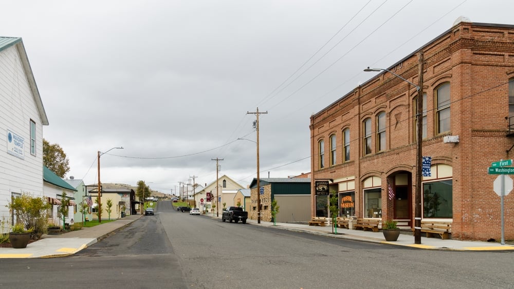
3. Fossil: A Journey Back in Time

Fossil, with a population of approximately 450, offers a unique blend of history and natural beauty. The town is famous for the Fossil Beds where visitors can dig for leaf fossils just behind the high school. Nearby attractions include the John Day Fossil Beds National Monument and the Painted Hills. The economy is supported by tourism, agriculture, and forestry. Fossil’s secluded charm comes from its rich paleontological significance and its setting amidst rolling hills and clear skies.
Where is Fossil?

Situated in Wheeler County, Fossil is about 140 miles east of Salem and is accessed via a network of scenic byways. The town’s remote location is underscored by vast stretches of open road and minimal traffic. The surrounding landscape of canyons and rock formations adds to the sense of isolation, making Fossil a perfect spot for those interested in geology and quiet exploration.
2. The Remote Beauty of Lakeview

Lakeview, known as the “Tallest Town in Oregon” due to its elevation of 4,800 feet, has a population of around 2,300. The town offers outdoor activities like hang gliding from the nearby Black Cap Mountain, soaking in Hunters Hot Springs, and exploring Goose Lake. Timber, agriculture, and geothermal energy are key industries. Lakeview’s seclusion is accentuated by the surrounding Warner Mountain Range and the expansive high desert, offering stunning vistas and a peaceful environment.
Where is Lakeview?

Located in Lake County, Lakeview is situated near the California border along Highway 395. The town’s remote position is emphasized by the long stretches of highway through high desert landscapes needed to reach it. Its proximity to natural attractions and the national forest lands adds to the feeling of being nestled away from the rest of the world. Visitors often find the journey to Lakeview a scenic adventure in itself.
1. The Hidden Gem of Burns

Burns, with a population of about 2,800, serves as a gateway to the vast and remote regions of southeastern Oregon. The town offers attractions like the Harney County Historical Museum and proximity to the Malheur National Wildlife Refuge, which is a haven for birdwatchers. Local industries include ranching, agriculture, and some manufacturing. Burns’ seclusion is defined by its expansive surrounding landscapes, wide-open skies, and a quiet, close-knit community atmosphere.
Where is Burns?

Burns is located in Harney County at the junction of Highways 20 and 395, about 130 miles east of Bend. The town’s remote location in Oregon’s largest county, which is also one of the least densely populated, contributes to its secluded character. The drive to Burns takes travelers through miles of high desert terrain, reinforcing the sense of distance from urban centers. This isolation makes Burns a perfect starting point for exploring the unspoiled natural beauty of Oregon’s high desert.